Jehanabad
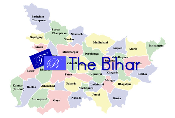
4 min readJehanabad is a city and a municipality in and the headquarters of Jehanabad district in the Indian state of Bihar. Earlier, Jehanabad was part of Gaya district. It is 50 km away from both Patna and Gaya.
History
Jehanabad District has own history from Mugal time. As per book “aine-e-akbari”, place was affected by famine in the 17th century and people were dying of hunger. The Mugal Emperor Aurangzeb, in whose time the book was re-written, established a Market(Mandi) for relief of the people and named the “Mandi” as “JAHANARA”( Aurangzeb’s Sister). The Mandi was managed under and supervised by Jahanara. She took a good interest in this. After some time the place came to be known as “JAHANARABAD” and later as “JEHANABAD”
Demographics
As of 2001 India census, Jehanabad had a population of 81,723. Males constitute 54% of the population and females 46%. Jehanabad has an average literacy rate of 63%, higher than the national average of 59.5%: male literacy is 70%, and female literacy is 54%. In Jehanabad, 16% of the population is under 6 years of age.now jehanabad is divided in to two parts, one is jehanabad other is arwal.
Natural Resources
The rivers- Falgu, Dardha, Jamuna and Morhar flow by crossing the district’s plan topography. The river Falgu has got religious importance where ‘PIND DAN’ is offered to their forefather’s by the Hindus. All these rivers are mainly rainfed, have a meagre discharge in the other parts of the year and go dry in the summers.
As far as minerals are concerned, the district has only minor ones. The sand available with the river beds in the major part of the year is collected and transported to other parts of the district besides to the adjoining districts and is useful in construction work. The hills of Barabar are being quarried for stones, which are utilised by 36 Crusher units, spread mainly across the Makhdumpur block.Barabar is a great tourist place of india. It has also a great history from the time of great samrat Ashok. Other religious places are the Mahavir Mandir, Babhana (2 km west from Jehanabad town) and Shri RamBag, Shahpur (5 km south-west from Jehanabad town). It is one of the most popular religious place of India. The soil is alluvial- textured brown gray which cracks open in the dry season and gets very sticky in the rains and the mud tracks become unmotorable during that period. The fertility is reasonably good. The forest cover of the district is small- 10.3 square kilometres, which is mainly concentrated near the Barabar Hills. They belong to the category of reserve forests.
Human resources
There are about 111,000 cultivators including 92138 small and marginal farmers, 178,000 agricultural labourers, 7969 skilled labours, 5075 house hold entrepreneurs and 95755 are engaged in allied agro business. The total population in the working age group is 358723 out of which there are 236199 males and 122534 females.
Infrastructure
The district is linked to the bigger cities of Patna & Gaya both by road and rail route. The recently electrified Patna-Gaya branch railway line (P.G. line) traverses through the district and links the Grand Chord with Patna. There are four railway stations- Jehanabad, Court, Tehta and Makhdumpur in the 31 km long stretch of the railways. National Highway No. 83 comes from Patna via Masaurhi, goes directly to Gaya through Makhdumpur and runs almost parallel to the railway line. There is a network of PWD roads and REO roads across the district, albeit in a bad shape. The total length of surfaced roads is 541.65 km and mud tracks is 450.90 km. The condition of the roads in the rural parts is good.
The district has wide network of markets dealing mainly with grains and vegetables. Major centers of trade and commerce are located in Jehanabad, Ghosi, Kako and Makhdumpur. Besides in rural areas hats function usually once in the week. The trade consists mainly of export of oil seeds, rice, gur, stone chips and vegetables. The principal imports are coal, cement and other construction materials, clothes, K. oil, tea, tobacco, fresh fruits and other perishable/ non perishable consumer goods.
The telecommunication network in the district is good. The whole of the district is either covered by basic or mobile/WLL phones. There are two WLL towers at Kako and Makhdumpur with 1500 line capacity, two mobile phone towers at Jehanabad and Ghoshi having capacity of 3100 lines and 14 exchanges for basic phone lines. The details have been provided in the annexures.
Jehanabad had a population of 81,723. Males constitute 54% of the population and females 46%. Jehanabad has an average literacy rate of 63%, higher than the national average of 59.5%: male literacy is 70%, and female literacy is 54%. In Jehanabad, 16% of the population is under 6 years of age.now jehanabad is divided in to two parts, one is jehanabad other is arwal.
Education
- Swami Sahjanand College,Jehanabad
- Krishna Mahila College, Jehanabad
- Anugrah Narayan College,Jehanabad
- S N Sinha College,Jehanabad
- R L S Y College,Jehanabad
- Jehanabad College, Jehanabad


